Toggle navigation
Suche
Indien
mehr darüber
Land
Afghanistan
Albanien
Algerien
Amerikanisch-Samoa
Andorra
Angola
Anguilla
Antigua und Barbuda
Argentinien
Armenien
Aruba Florin
Aserbaidschan
Australien
Ägypten
Äquatorialguinea
Äthiopien
Bahamas
Bahrain
Bangladesch
Barbados
Belarus (Weißrussland)
Belgien
Belize
Benin
Bermuda
Bhutan
Bolivien
Bosnien und Herzegowina
Botsuana
Brasilien
Brunei
Bulgarien
Burkina Faso
Burundi
Chile
China
Cookinseln
Costa Rica
Cote d`voire (Elfenbeinküste)
Demokratische Republik Kongo
Deutschland
die Schweiz
Dominica
Dominikanische Republik
Dschibuti
Dänemark
Ecuador
El Salvador
Eritrea
Estland
Falklandinseln
Fidschi
Finnland
Frankreich
Französische Guiana
Französische Polinesien
Färöer
Gabon
Gambia
Georgien
Ghana
Gibraltar
Grenada
Griechenland
Großbritanien (Vereinigtes Königreich)
Grönland
Guadeloupe
Guam
Guatemala
Guernsey
Guinea
Guinea-Bissau
Guyana
Haiti
Honduras
Hong Kong
Indien
Indonesien
Irak
Iran
Irland
Island
Israel
Italien
Jamaika
Japan
Jemen
Jersey
Jordanien
Jungferninseln (USA)
Kaimaninseln
Kambodscha
Kamerun
Kanada
Kap Verde
Kasachstan
Katar
Kenia
Kirgisien
Kiribati
Kokosinseln
Kolumbien
Komoren
Kroatien
Kuba
Kuwait
Laos
Lesotho
Lettland
Libanon
Liberia
Libyen
Liechtenstein
Litauen
Luxemburg
Madagaskar
Makao
Malawi
Malaysia
Malediwen
Mali
Malta
Marokko
Marshallinseln
Martinique
Mauretanien
Mauritius
Mayotte
Mazedonien
Mexico
Mikronesien
Moldawien
Monaco
Mongolei
Montenegro
Montserrat
Mosambik
Myanmar
Namibia
Nauru
Nepal
Neukaledonien
Neuseeland
Nicaragua
Niederlande
Niederländische Antillen
Niger
Nigeria
Niue
Nordkorea
Norfolkinsel
Norwegen
Nördliche Marianen
Oman
Osttimor
Österreich
Pakistan
Palau
Panama
Papua-Neuguinea
Paraguay
Peru
Philippinen
Pitcairn-Inseln
Polen
Portugal
Puerto Rico
Republik Kongo
Reunion
Ruanda
Rumänien
Russland
Saint Helena
Saint Kitts und Nevis
Saint Lucia
Saint Pierre und Miquelon
Saint Vincent und die Grenandinen
Sambia
Samoa
San Marino
Sao Tome und Principe
Saudi-Arabien
Schweden
Senegal
Serbien
Seychellen
Sierra Leone
Simbabwe
Singapur
Slowakei
Slowenien
Solomonen-Inseln
Somalien
Spanien
Sri Lanka
Sudan
Suriname
Svalbard
Swasiland
Syrien
Südafrika
Südkorea
Tadschikistan
Taiwan
Tansanien
Thailand
Togo
Tokelau
Tonga
Trinidad und Tobago
Tschad
Tschechische Republik
Tunesien
Turkmenistan
Turks- und Caicosinseln
Tuvalu
Türkei
Uganda
Ukraine
Ungarn
Uruguay
Usbekistan
Vanuatu
Venezuela
Vereinigte Arabische Emiraten
Vereinigte Staaten von Amerika (USA)
Vietnam
Wallis und Futuna
Weihnachtsinsel
Westsahara
Zentralafrikanische Reepublik
Zypern
Neudelhi
mehr darüber
Stadt
Agra
Ahmedabad
Amritsar
Bangalore
Bhopal
Bhubaneswar
Bombay
Chennai
Goa
Hyderabad
Indore
Jaipur (Dschaipur)
Jodhpur
Kalkutta
Kalyan
Kanpur
Lucknow
Madurai
Moradabad
Nainital
Neudelhi
Pune
Thiruvananthapuram (Trivandrum)
Udaipur
Visakhapatnam
Kostenlose Werbung
Kontakte
Pukpui Helipad
Indien
List of airports Indien
Pukpui Helipad
Weitere Informationen über airport - Pukpui Helipad, Indien
Beschreibung
Wert
IATA
(IATA-Flughafencode)
Kein IATA-code
Typ
Hubschrauberlandeplatz
Flughafencode
-
GPS-Airport-code
Längengrad
22.9422666667
Breitengrad
92.76885
Bilder in der Nähe Pukpui Helipad, Indien
Bilder von Pukpui Helipad
Informationsmaterial - Neudelhi
Preise, Lebenshaltungskosten Neudelhi
Lokalzeit, Die Zeit in Neudelhi
Zeitzone - Neudelhi, Indien
Wetter - Neudelhi, Indien
Karte von Neudelhi
Nationalflagge Indien
Neudelhi - telefonvorwahl, wie aufruf Neudelhi
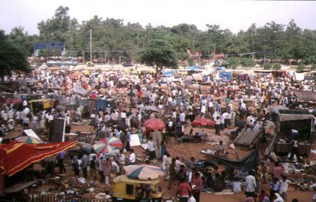
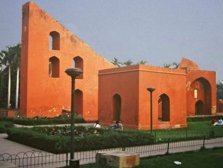
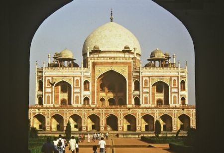
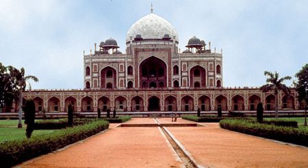
Bilder von Neudelhi
Entfernungen von Neudelhi, Indien
Informationsmaterial - Indien
Währung Indien, Indische Rupie
Währungsrechner Indische Rupie
Botschaften Indien
Karte von Indien
Liste der Flughäfen Indien
Fotogalerie
Indien, Neudelhi
Fügen Sie Ihr Foto
Bilder von Neudelhi »